Indian public has something to thank Google for after the initial furore in the country over their high resolution satellite photographs of sensitive defence sites
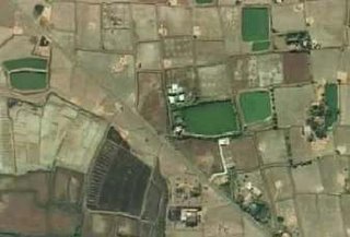
Farmers in Pen Taluka in the Raigad district of Maharashtra state have produced Google Earth pictures as evidence of their stand in the case currently filed against the Maharashtra government seeking higher compensation for their agricultural lands.
The Maharashtra government had targeted lands in 45 villages of this district to embark on its Maha Mumbai Special Economic Zone (SEZ) project to give industrialization a jump start. During the process of acquiring land, the government claimed that most of the land in the areas surrounding the villages were infertile and and that some parts of it were submerged by salty creek water. This claim, translated to a lower compensation for the farmers.
That's when an activist of the SEZ Hatao Virodh Samiti (Remove SEZ Committee) , Arun Shivkar, logged on to Google Earth. What Google Earth showed were clear high resolution pictures that indicated that most of the land was indeed fertile and actively covered by crop. This single act has also united the farmers in their stand seeking a higher compensation than that being given currently by the state government.

Amazing what technology can do when harnessed for purposes like these. Clearly, Google might not have even envisioned itself as the saviour of these farmers who had been pushed to a corner and appeared to be fighting a losing battle.
Click here to watch the video by CNN-IBN
Comments
Hats off to the ingenious farmers...Long live India